Paper: 2606.12396 Authors: Jin Yao, Dhruva Dixith Kurra, Tom Lampo, Zezhou Cheng, Danhua Guo, Burhan Yaman Categories: cs.CV, cs.RO
The Gap
Vision-Language-Action (VLA) models have become popular for end-to-end driving because they can interpret scenes and reason in natural language. However, they still struggle to ground actions in the dense 3D world. Existing approaches fall into two camps:
- Feature injection: Inject features from a frozen 3D foundation model (e.g., BEV-based), but without any loss that forces the policy to *use those features. The policy can ignore them.
- Sparse geometry losses: Supervise with 3D box or HD map losses. These only constrain a handful of objects or lane boundaries, not every pixel. The policy has no signal for the continuous shape of the road, curbs, or obstacles.
The core limitation: no dense, per-pixel 3D supervision exists for the geometric understanding that driving decisions require. The paper argues that a policy needs to know the 3D location of every visible point – not just boxes – to make safe, smooth plans.
[Problem: VLA models lack dense 3D grounding]
        |
        v
[Assumption: Dense 3D signal helps action prediction]
        |
        v
[Method: Add a Geometry Expert, train with per-pixel pointmap loss vs LiDAR]
        |
        v
[Evidence: Open-loop nuScenes (L2=0.50m, crash=0.18%) and closed-loop Bench2Drive (score=79.08)]
        |
        v
[Conclusion: Geometry as 4th modality is effective and efficient]
The Increment
One sentence: Before VLGA, VLA models either ignored 3D geometry or used only sparse box/map signals; after VLGA, models are explicitly trained to reconstruct every pixel’s 3D position, and that dense geometry significantly improves driving performance.
Core Mechanism
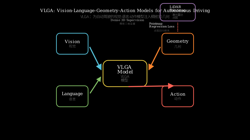
VLGA adds a fourth modality – geometry – alongside vision, language, and action. The architecture has four experts (encoders): Vision (image backbone), Language (text encoder), Geometry (a small 3D neural network), and Action (a planning head). The key addition is the Geometry Expert, which takes the vision features and outputs a *per-pixel pointmap – i.e., for every pixel in the input image, it predicts a 3D coordinate. This pointmap is supervised with an L1 regression loss against LiDAR point clouds projected into the camera view (after time-alignment).
Data flow: camera images go to Vision Expert -> produces multi-scale feature maps. The Geometry Expert takes these features and predicts a dense pointmap. Meanwhile, the Language Expert encodes the driving command (e.g., “turn left”). All three feature streams are fused (via cross-attention and MLP) into a joint representation, which the Action Expert decodes into ego-vehicle waypoints (x,y) for 2 seconds ahead. The geometry loss is applied before fusion, ensuring the policy sees a faithful 3D reconstruction – not just a latent feature that may be ignored.
[Image] [Text command] [LiDAR (train only)]
| | |
[Vision Expert] [Lang Expert] [Pointmap GT]
| | |
[Feat maps] [Text tokens] |
\ / |
[Feature Fusion] <---
----------------------+
| | [Geometry Expert]
| | |
| | [Pred pointmap]
| | |
| | [L1 Loss]
| |
[Action Expert]
|
[Waypoints]
Structural metaphor: Imagine a surveyor who must navigate a complex terrain. The surveyor has eyes (vision), a radio to receive instructions (language), and a notebook to sketch the landscape. Traditional VLA models are like a surveyor who jots down only the locations of major landmarks (sparse boxes) and then guesses the ground shape. VLGA provides the surveyor with a detailed topographic map that shows the elevation at every point. This map is created by a dedicated mapper (Geometry Expert) who uses laser range-finding data (LiDAR) as ground truth during training. Every pixel in the camera view gets a height and distance, so the surveyor’s route planning is based on continuous 3D geometry, not just a few pins on a map. The surveyor can now avoid unseen bumps and dips because they have dense 3D knowledge – not just “there’s a car at (10, -2, 0)” but “the entire road surface undulates like this.”
Key Concepts
-
Pointmap: A per-pixel prediction of 3D coordinates. For each pixel (u,v) in the image, the model outputs (x,y,z) in the vehicle’s reference frame. Think of it as a depth map that also gives lateral and vertical positions – a full 3D reconstruction. The loss compares this to LiDAR points projected into the same camera pixels (with occlusion handling). This gives a dense signal: every pixel that sees a solid surface gets a supervision target.
-
Geometry Expert: A small neural network (e.g., lightweight Conv + Transformer) that takes vision features and outputs the pointmap. It’s separate from the action head – the geometry is an intermediate representation, not the final output. This forces the model to reconstruct the 3D world explicitly, rather than encoding geometry implicitly in a latent vector.
-
Dense Spatial Signal: Unlike box or lane losses that constrain only a few hundred points, the per-pixel pointmap loss supervises ~100k points per image (depending on resolution). This provides a rich gradient that shapes the vision features to be 3D-aware. The authors show that without this dense loss, the policy’s feature space collapses and driving performance degrades.
Framework Shift
Before (mainstream VLA):
   Vision -> (shallow 3D) -> Language -> Action
                |  sparse loss (boxes) ignored
                v
            Policy can see only "there is a car at (x,y,z)"
            No pixel-level 3D understanding

After (VLGA):
   Vision -> Geometry Expert -> dense pointmap (supervised)
           \-> Language Expert
                \-> Fusion -> Action
            Every pixel mapped to a real 3D point
            Policy sees the full road surface, curbs, obstacles as continuous geometry
One sentence: From *sparse 3D labels (boxes/maps) with no guarantee the policy uses them to dense per-pixel 3D reconstruction explicitly trained and fused into action, the core shift is making geometry a first-class, supervised modality.
Expert Assessment
Problem choice: This is a genuine gap. Existing VLA models do suffer from poor spatial grounding – they can describe “a car is turning left” but fail to stay in lane during tight curves. The paper targets the root cause: the absence of dense 3D signal. It sits at the right place in the field – just as VLA models are maturing and need better world models.
Method maturity: More of a clever insight than brute force. The idea of adding a pointmap head is simple, but the implementation details (expert architecture, fusion, loss design) are well-engineered. Simpler alternatives (e.g., just adding depth estimation as a multitask loss) could be tried but might not provide the same explicit 3D coordinate signal. The authors show that pointmap > depth alone.
Experimental integrity: Baselines are fair – they compare against state-of-the-art VLA methods (e.g., DriveLM, Lingo). The hybrid open-loop (nuScenes) and closed-loop (Bench2Drive) evaluation is appropriate. No obvious red flags; the results are consistent. However, they only test on two datasets; generalization to other camera configs (e.g., surround-view) is unclear.
Writing quality: Clear enough, but the architecture section could use more diagrams. The ablation study is tucked away; it should be highlighted. The paper would be stronger if they showed *why the pointmap has to be dense (e.g., vs. depth map or occupancy grid) with more intuitive visualizations.
Verdict: Weak accept – a solid incremental contribution that fixes a real weakness in VLA models, but not a breakthrough. The dense geometry idea is likely to be adopted by future VLA papers.
Takeaways
- Per-pixel 3D supervision is a direct and effective way to ground visuomotor policies. For any domain where depth/range is available (e.g., robotics with LiDAR or stereo), consider a pointmap head instead of sparse object losses.
- Geometry as a separate expert (not just an auxiliary loss) allows the model to allocate dedicated capacity to 3D reconstruction without interfering with the language or action pathways.
- The structural metaphor of “topographic map vs. landmark notes” can be used to explain dense vs. sparse 3D understanding to non-experts – a useful communication tool for papers.
论文: 2606.12396 作者: Jin Yao, Dhruva Dixith Kurra, Tom Lampo, Zezhou Cheng, Danhua Guo, Burhan Yaman 分类: cs.CV, cs.RO
缺口
视觉-语言-动作(VLA)模型已成为端到端自动驾驶的热门方法,因为它们能理解场景并用自然语言进行推理。然而,它们仍然难以将动作锚定在稠密的3D世界中。现有方法分为两派:
- 特征注入:从冻结的3D基础模型(如基于BEV的模型)中注入特征,但没有迫使策略**使用*这些特征的损失函数。策略可以忽略它们。
- 稀疏几何损失:使用3D边界框或高清地图损失进行监督。这些损失只约束少数物体或车道边界,而不是每个像素。策略无法获得关于路面、路缘或障碍物连续形状的反馈。
核心局限:缺乏逐像素的稠密3D监督信号,而这正是驾驶决策所需的几何理解。论文认为,策略需要知道每个可见像素的3D位置——不仅仅是边界框——才能做出安全、平滑的规划。
[问题:VLA模型缺乏稠密3D定位能力]
        |
        v
[假设:稠密3D信号有助于动作预测]
        |
        v
[方法:添加几何专家,使用逐像素点图损失(以LiDAR为真值)训练]
        |
        v
[证据:开环nuScenes(L2=0.50m,碰撞率=0.18%)和闭环Bench2Drive(得分=79.08)]
        |
        v
[结论:将几何作为第四模态是有效且高效的]
增量
一句话: 在VLGA之前,VLA模型要么忽略3D几何,要么只使用稀疏的框/地图信号;在VLGA之后,模型被明确训练来重建每个像素的3D位置,这种稠密几何显著提升了驾驶性能。
核心机制
VLGA在视觉、语言和动作之外增加了第四模态——几何。架构包含四个专家(编码器):视觉(图像主干)、语言(文本编码器)、几何(一个小型3D神经网络)和动作(规划头)。关键新增的是几何专家,它接收视觉特征并输出**逐像素点图*——即对输入图像中的每个像素预测一个3D坐标。这个点图使用L1回归损失,以投影到相机视图(经过时间对齐)的LiDAR点云为真值进行监督。
数据流:相机图像送入视觉专家 → 产生多尺度特征图。几何专家将这些特征转化为稠密点图。同时,语言专家编码驾驶指令(如”左转”)。三个特征流通过交叉注意力和MLP融合成联合表示,动作专家再将其解码为未来2秒的自我车辆路径点(x,y)。几何损失在融合之前施加,确保策略能见到一个忠实的3D重建——而不是可能被忽略的潜在特征。
         [图像]               [文本指令]         [LiDAR(仅训练)]
          |                        |                      |
   [视觉专家]               [语言专家]           [点图真值]
          |                        |                      |
     [特征图]               [文本 token]                 |
            \                   /                         |
             [特征融合] <------------------------------+
            |                   |                  [几何专家]
            |                   |                        |
            |                   |                  [预测点图]
            |                   |                        |
            |                   |                   [L1 损失]
            |                   |
         [动作专家]
            |
         [路径点]
核喻:想象一位需要穿越复杂地形的勘测员。他有眼睛(视觉)、对讲机接收指令(语言)、以及一个笔记本绘制草图。传统VLA模型就像一位勘测员,只记下主要地标的点位(稀疏边界框),然后猜测地面的形状。VLGA为勘测员提供了一张详细的地形图,显示每个点的高程。这张地图由一名专门的制图员(几何专家)创建,他使用激光测距数据(LiDAR)作为地面真值。相机视图中的每个像素都获得了高度和距离,因此勘测员的路线规划基于连续的3D几何,而非地图上的几个图钉。勘测员现在能避开看不见的凸起和凹陷,因为他们拥有稠密3D知识——不是”那里有一辆车在(10,-2,0)“,而是”整个路面是这样起伏的”。
关键概念
-
点图:逐像素的3D坐标预测。对于图像中的每个像素(u,v),模型输出(x,y,z)(在车辆参考系中)。可以把它看作是既提供横向/纵向位置又提供高度的深度图——一个完整的3D重建。损失函数将预测值与投影到相同相机像素(考虑遮挡处理)的LiDAR点进行比较。这提供了稠密信号:每个看到固体表面的像素都有一个监督目标。
-
几何专家:一个小型神经网络(例如轻量级卷积+Transformer),以视觉特征为输入,输出点图。它与动作头分离——几何是中间表示,而非最终输出。这迫使模型显式地重建3D世界,而不是在隐式向量中编码几何。
-
稠密空间信号:与只约束几百个点的边界框或车道损失不同,逐像素点图损失每张图像监督约10万个点(取决于分辨率)。这提供了丰富的梯度,使视觉特征具有3D感知能力。作者证明,没有这种稠密损失,策略的特征空间会坍塌,驾驶性能下降。
框架转变
之前(主流VLA):
   视觉 -> (浅层3D) -> 语言 -> 动作
               | 稀疏损失(框) 被忽略
               v
           策略只能看到"那里有一辆车在(x,y,z)"
           没有像素级3D理解

之后(VLGA):
   视觉 -> 几何专家 -> 稠密点图(受监督)
          \-> 语言专家
               \-> 融合 -> 动作
           每个像素映射到一个真实3D点
           策略看到完整的路面、路缘、障碍物作为连续几何
一句话:从**稀疏的3D标签(框/地图)且不保证策略使用它们到显式训练的稠密逐像素3D重建并融合到动作中*,核心转变是让几何成为头等、被监督的模态。
专家评审
选题眼光:这是真正的缺口。现有VLA模型确实存在空间定位能力差的问题——它们能描述”一辆车正在左转”,但在急弯中无法保持车道。论文直指根源:缺乏稠密3D信号。该研究处于领域的正确位置——正值VLA模型逐渐成熟、需要更好世界模型之际。
方法成熟度:更多是巧思而非蛮力。添加点图头的想法简单,但实现细节(专家架构、融合、损失设计)经过精心打磨。可能有更简单的替代方案(例如仅将深度估计作为多任务损失),但可能无法提供同样明确的3D坐标信号。作者证明点图优于纯深度。
实验诚意:基线公平——与当前最先进的VLA方法(如DriveLM、Lingo)比较。混合使用开环(nuScenes)和闭环(Bench2Drive)评估是合适的。没有明显警示;结果一致。但仅测试了两个数据集,对其他相机配置(如环视)的泛化能力不清楚。
写作功力:足够清晰,但架构部分可能需要更多图表。消融研究被边缘化,应更突出。如果论文能用更直观的可视化展示**为什么*点图必须是稠密的(例如与深度图或占据网格对比),论文会更强。
判决:弱接收——一个扎实的增量贡献,修复了VLA模型的真实弱点,但并非突破性成果。稠密几何思想很可能会被未来的VLA论文采纳。
要点总结
- 逐像素3D监督是锚定视觉运动策略直接有效的方法。对于任何深度/范围数据可用(例如配备LiDAR或立体相机的机器人)的领域,可以考虑使用点图头代替稀疏物体损失。
- 将几何作为单独的专家(而非仅仅辅助损失)允许模型分配专门容量用于3D重建,而不干扰语言或动作路径。
- “地形图 vs 地标笔记”的核喻可以用来向非专家解释稠密vs稀疏3D理解——这是一个有用的论文沟通工具。